
Forecasters Only
Weather Forecasting Information
BUFFALO WEATHER SITE
Buffalo Weather Service Website
RADAR
SATELLITE
CURRENT WEATHER
Current US Weather (Zoom into New York)
LIGHTNING
New York Map - Live
T-STORM / TORNADO GUIDANCE
Storm Prediction Center - Monitors Severe T-storms and Tornadoes
Storm Predication Center Storm Outlook
DAMAGE REPORTS
COMPUTER MODELS
HRRR Rapid Computer Forecasting Model
Local NAM Mesoscale Model Run Buf
WFR-EMS Local Computer Forecasting Model
NAM / GFS Computer Forecasting Model Views
MFR Computer Forecasting Model
ECMWF Computer Forecasting Model
National Weather Service Model View
Liquid Precip Forecasts / Motion
NAM Model Snowfall - Buffalo NY View
NAM Model Snowfall - Binghamton NY View
GFS Model Snowfall - Buffalo NY View
GFS Model Snowfall - Binghamton NY View
NWS Buffalo Graphical Forecasts
MARINE
Marine Text Forecast from Buffalo NWS
Northeastern lake Ontario Buoy
FORECAST HELP
National Weather Service Forecast Buffalo
Climate Prediction Center - Outlooks
Area School Closings - 13 WHAM TV
Severe Weather Terms and Conditions

High Pressure System: This is a region of relatively higher air pressure. There will often be sinking air and thus stable weather. Sunny /clear weather will often occur under high pressure. High pressure is colored in blue. The choice of the color blue has nothing to do with temperature. High pressures can bring with warm or cold weather depending on the type of high pressure it is.

Low Pressure System: This is a region of relatively lower air pressure. There will be rising air and thus often there will also be clouds and widespread precipitation. Low pressure is colored in red. The choice of the color red has nothing to do with temperature. While it is typically cooler under a low due to the the cooling from cloud cover as well as rain or snow, temperatures can vary between being mild to being very cold.

Cold Front: A cold front indicates a colder air mass is moving in the direction toward which the triangles are pointing. The cold front is drawn at the leading edge of the cold air mass. When the cold front passes the temperature drops and the rising air along the front can bring scattered or shorter lasting periods of precipitation, especially in the region where the cold front is approaching and along the front itself.

Warm Front: A warm front indicates a warmer air mass is moving in the direction toward which the semicircles are pointing. The warm front is drawn at the leading edge of the warm air mass. A warm front can also bring precipitation especially in the region where the warm front is approaching and along the front itself. .

Stationary Front: A stationary front separates a warmer from a cooler air mass. A stationary front has a little or no movement thus the cold and warm front symbols are drawn in alternating fashion. This type of front can prodcue long periods of precipitation.

Occluded Front: An occluded front is drawn in purple. It is a cold front that overtakes a warm front. They commonly occur close to a maturing low pressure system and can produce precipitation.

RADAR
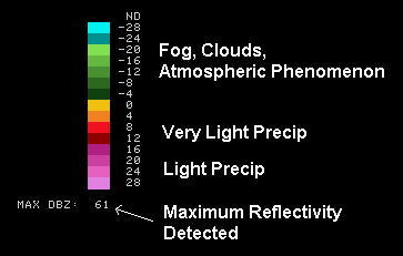
Clear Air Mode Scale:
Precipitation Mode Scale:
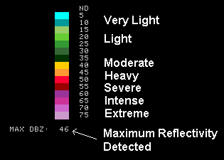
| What do the colors mean in the reflectivity products? The colors are the different echo intensities (reflectivity) measured in dBZ (decibels of Z) during each elevation scan. "Reflectivity" is the amount of transmitted power returned to the radar receiver. Reflectivity (designated by the letter Z) covers a wide range of signals (from very weak to very strong). So, a more convenient number for calculations and comparison, a decibel (or logarithmic) scale (dBZ), is used.
The dBZ values increase as the strength of the signal returned to the radar increases. Each reflectivity image you see includes one of two color scales. One scale (far left) represents dBZ values when the radar is in clear air mode (dBZ values from -28 to +28). The other scale (near left) represents dBZ values when the radar is in precipitation mode (dBZ values from 5 to 75). Notice the color on each scale remains the same in both operational modes, only the values change. The value of the dBZ depends upon the mode the radar is in at the time the image was created. The scale of dBZ values is also related to the intensity of rainfall. Typically, light rain is occurring when the dBZ value reaches 20. The higher the dBZ, the stronger the rainrate. Depending on the type of weather occurring and the area of the U.S., forecasters use a set of rainrates which are associated to the dBZ values. These values are estimates of the rainfall per hour, updated each volume scan, with rainfall accumulated over time. Hail is a good reflector of energy and will return very high dBZ values. Since hail can cause the rainfall estimates to be higher than what is actually occurring, steps are taken to prevent these high dBZ values from being converted to rainfall. |
|||||||||||||||||||||||||||||||
| What do the colors mean in the velocity images? Each velocity image includes one of two velocity scales regardless of the radar's operation mode. One scale (far left) represents radial velocities in the base velocity image. The other scale (near left) represents the "storm relative motion" radial velocities. Note: As in the case of reflectivity images, the color on each scale remains the same in both velocity images, only the values change. The velocity of the wind is measured in knots (1 knot = 1.15 mph). Since these colors represent values relative to the radar, to interpret these images correctly, it is most important to know where the radar is located each velocity image. For example, a region with outbound wind in one radar will be represented by red colors. That same region's wind could be inbound on an adjacent radar image and represented by green colors. |
|
FORCE 0 |
LESS THAN 1 KNOT |
SEA LIKE A MIRROR |
|
FORCE 1 |
1 - 3 KNOTS |
WAVE HEIGHT .1 M(.25 FT.); RIPPLES WITH APPEARANCE OF SCALES, NO FOAM CRESTS. |
|
FORCE 2 |
4 - 6 KNOTS |
WAVE HEIGHT .2 - .3 (.5 - 1 FT.); SMALL WAVELETS, CRESTS OF GLASSY APPEARANCE, NOT BREAKING. |
|
FORCE 3 |
7 - 10 KNOTS |
WAVE HEIGHT .6 - 1 M (2 - 3 FT.); LARGE WAVELETS, CRESTS BEGIN TO BREAK, SCATTERED WHITECAPS. |
|
FORCE 4 |
11 - 16 KNOTS |
WAVE HEIGHT 1 - 1.5 M (3.5 - 5 FT.); SMALL WAVES BECOMING LONGER, NUMEROUS WHITECAPS. |
|
FORCE 5 |
17 - 21 KNOTS |
WAVE HEIGHT 2 - 2.5 M (6 - 8 FT.); MODERATE WAVES, TAKING LONGER FORM, MANY WHITECAPS, SOME SPRAY. |
|
FORCE 6 |
22 - 27 KNOTS |
WAVE HEIGHT 3 - 4 M (9.5 - 13 FT.); LARGER WAVES FORMING, WHITECAPS EVERYWHERE, MORE SPRAY. |
|
FORCE 7 |
28 - 33 KNOTS |
WAVE HEIGHT 4 - 5.5 M (13.5 - 19 FT.); SEA HEAPS UP, WHITE FORM FROM BREAKING WAVES BEGINS TO BE BLOWN IN STREAKS ALONG DIRECTION OF WIND. |
|
FORCE 8 |
34 - 40 KNOTS |
WAVE HEIGHT 5.5 - 7.5 M (18 - 25 FT.); MODERATELY HIGH WAVES OF GREATER LENGTH, EDGES OF CRESTS BEGIN TO BREAK INTO SPINDRIFT, FOAM IS BLOWN IN WELL MARKED STREAKS. |
|
FORCE 9 |
41 - 47 KNOTS |
WAVE HEIGHT 7 - 10 M (23 - 32 FT.); HIGH WAVES, SEA BEGINS TO ROLL, DENSE STREAKS OF FOAM ALONG WIND DIRECTION, SPRAY MAY REDUCE VISIBILITY. |
|
FORCE 10 |
48 - 55 KNOTS |
WAVE HEIGHT 9 - 12.5 M (29 - 41 FT.); VERY HIGH WAVES WITH OVERHANGING CRESTS, SEA TAKES WHITE APPEARANCE AS FOAM IS BLOWN IN VERY DENSE STREAKS, ROLLING IS HEAVY AND SHOCKLIKE, VISIBILITY IS REDUCED. |
|
FORCE 11 |
56 - 63 KNOTS |
WAVE HEIGHT 11.5 - 16 M (37 - 52 FT.); EXCEPTIONALLY HIGH WAVES, SEA COVERED WITH WHITE FOAM PATCHES, VISIBILITY IS STILL MORE REDUCED. |
